 NASA/JPL/Arizona State University
|
|
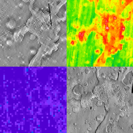
FOUR WAYS OF SEEING MARS
Map Cutter extracted the same area centered around Hydraotes Chaos from four different Mars data sets (out of a total of 26 global data sets). Clockwise from top left, these data maps show nighttime infrared, thermal inertia, daytime infrared, and olivine abundance. Click the image for a larger version.
|
|
|
|
THEMIS Mosaic Tools
The THEMIS Science Team is developing software tools to help users make Mars mosaics easily. Currently available:
Map Cutter - Use latitude and longitude to extract areas of interest from various planetwide Mars data maps such as THEMIS daytime infrared, MOLA color elevation, TES mineral abundance, and others.
More tools on the way!
|
|