Googling Mars
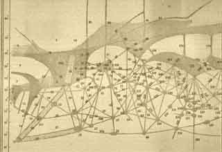
In 1895, Percival Lowell published his map of Mars. He spent many years of his life exploring Mars through his telescope. Now you can explore Mars too, through your browser. Google Mars is the result of collaborations between Google and us. With it, you can explore some of the most detailed scientific maps of Mars ever made.
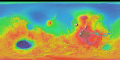
At the heart of Google Mars is a gigantic mosaic image of Mars. Using over 17,000 individual infrared photos, we assembled the mosaic at a scale that resolves features as small as 230 meters (750 feet) across. The images come from THEMIS, the Thermal Emission Imaging System, a camera that takes photos in 5 visible and 10 infrared bands. It is orbiting Mars aboard NASA's Mars Odyssey.
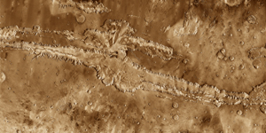
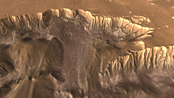
In addition, embedded within Google Mars is the most detailed image ever made of Valles Marineris, the Red Planet's "Grand Canyon." Researchers at the Mars Space Flight Facility built this mosaic image from over 500 separate photos, revealing landscape features only 100 meters (330 feet) across.
The Valles Marineris mosaic led naturally to another project of ours, carried out in collaboration with a team from the Jet Propulsion Laboratory's Digital Image Animation Laboratory. The result was Flight Into Mariner Valley, a computer-animated movie that takes viewers on a simulated flight through Valles Marineris.